What words one uses to describe the Arab-Israeli conflict affects the content of one's argument. I review a number of contentious words today in an article titled "Palestinian Word Games." One topic does not fit there, namely West Bank vs. Judea and Samaria.
I get admonished occasionally for using the term West Bank and not (as many who think like me do) Judea and Samaria. Here's why:
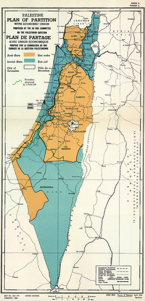
(1) Judea and Samaria only approximates the area defined in the 579-word paragraph in United Nations General Assembly Resolution 181 that partitioned Palestine and created the West Bank. It reads in full:
 The UN Partition Plan for Palestine adopted on Nov. 29, 1947. Note that it differs from the "West Bank" agreed upon in the General Armistice Agreement signed on Apr. 3, 1949, and under Jordanian control from 1949 to 1967. |
The boundary of the hill country of Samaria and Judea starts on the Jordan River at the Wadi Malih south-east of Beisan and runs due west to meet the Beisan-Jericho road and then follows the western side of that road in a north-westerly direction to the junction of the boundaries of the sub-districts of Beisan, Nablus, and Jenin. From that point it follows the Nablus-Jenin sub-district boundary westwards for a distance of about three kilometres and then turns north-westwards, passing to the east of the built-up areas of the villages of Jalbun and Faqqu'a, to the boundary of the sub-districts of Jenin and Beisan at a point north-east of Nuris. Thence it proceeds first north-westwards to a point due north of the built-up area of Zir'in and then westwards to the Afula-Jenin railway, thence north-westwards along the district boundary line to the point of intersection on the Hejaz railway. From here the boundary runs south-westwards, including the built-up area and some of the land of the village of Kh.Lid in the Arab State to cross the Haifa-Jenin road at a point on the district boundary between Haifa and Samaria west of El Mansi. It follows this boundary to the southernmost point of the village of El Buteimat. From here it follows the northern and eastern boundaries of the village of Ar'ara, rejoining the Haifa-Samaria district boundary at Wadi'Ara, and thence proceeding south-south-westwards in an
approximately straight line joining up with the western boundary of Qaqun to a point east of the railway line on the eastern boundary of Qaqun village. From here it runs along the railway line some distance to the east of it to a point just east of the Tulkarm railway station. Thence the boundary follows a line half-way between the railway and the Tulkarm-Qalqiliya-Jaljuliya and Ras el Ein road to a point just east of Ras el Ein station, whence it proceeds along the railway some distance to the east of it to the point on the railway line south of the junction of the Haifa-Lydda and Beit Nabala lines, whence it proceeds along the southern border of Lydda airport to its south-west corner, thence in a south-westerly direction to a point just west of the built-up area of Sarafand el'Amar, whence it turns south, passing just to the west of the built-up area of Abu el Fadil to the north-east corner of the lands of Beer Ya'Aqov. (The boundary line should be so demarcated as to allow direct access from the Arab State to the airport.) Thence the boundary line follows the western and southern boundaries of Ramle village, to the north-east corner of El Na'ana village, thence in a straight line to the southernmost point of El Barriya, along the eastern boundary of that village and the southern boundary of 'Innaba village. Thence it turns north to follow the southern side of the Jaffa-Jerusalem road until El Qubab, whence it follows the road to the boundary of Abu Shusha. It runs along the eastern boundaries of Abu Shusha, Seidun, Hulda to the southernmost point of Hulda, thence westwards in a straight line to the north-eastern corner of Umm Kalkha, thence following the northern boundaries of Umm Kalkha, Qazaza and the northern and western boundaries of Mukhezin to the Gaza District boundary and thence runs across the village lands of El Mismiya, El Kabira, and Yasur to the southern point of intersection, which is midway between the built-up areas of Yasur and Batani Sharqi.
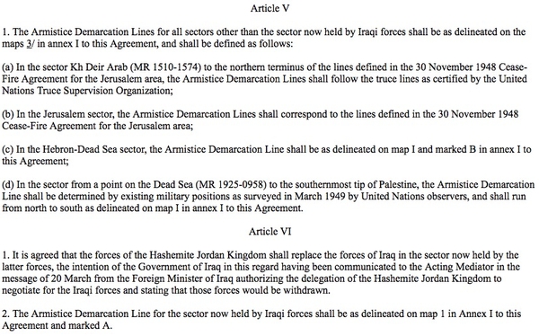
The map accompanying the General Armed Armistice signed by Israel and Jordan on Apr. 3, 1949.
(2) To the point that UNGA Resolution 181 contains the words "the hill country of Samaria and Judea," I reply: Those seven words are only a vague reference, not a precise or technical one, that make up only about 1 percent of the geographic definition of the area called the West Bank. Another 572 words are needed to fill out that area's description.
(3) The "West Bank" that the Jordanian monarchy controlled in 1949-67 has, so far as I am aware, no precise definition but was based on the de facto armistice lines noted in the General Armistice Agreement signed between the Israeli and Jordanian governments on Apr. 3, 1949.

"West Bank" trips off the tongue a bit more easily than the above huge paragraph and is far more accurate than "Judea and Samaria," so it is not tantamount to adopting the Palestinian narrative but being historically and geographically precise. Therefore, I use the term West Bank.
June 22, 2023 update: The writer who goes by Hugh Fitzgerald has laid down the law: "Why Israel Must Stop Using 'West Bank' for 'Judea and Samaria': Reject the sinister "Palestinian" propaganda." He even asserts that
anyone who still refuses to use the terms "Judea and Samaria" after having been made aware of the propaganda purpose and effect of "the West Bank," deserves to be named and shamed.
I plead guilty.
Dec. 5, 2024 update: Sen. Tom Cotton (Republican of Arkansas) has
introduced the Retiring the Egregious Confusion Over the Genuine Name of Israel's Zone of Influence by Necessitating Government-use of Judea and Samaria (RECOGNIZING Judea and Samaria) Act, legislation to require all official U.S. documents and materials to use the historically accurate term "Judea and Samaria" instead of the "West Bank". This bill would require the use of historically accurate terminology and align U.S. policy language with the geographical and cultural significance of the region. This legislation was introduced in the House by Congresswoman Claudia Tenney (R-New York).
Comment: I admire the spirit but disagree with the technicalities.
Jan. 31, 2025 update: Congressional Republicans have finalized the "Recognizing Judea and Samaria Act." It prohibits U.S. government use of the term West Bank.
